GALAPAGOS, EQUADOR
I have a whole new respect for the challenges faced with composing underwater photographs in the Galapagos.

Macro
5/10
Wide
9/10
Diversity
8/10
Abundance
10/10
Health
8/10
SURVIVAL OF THE FITTEST
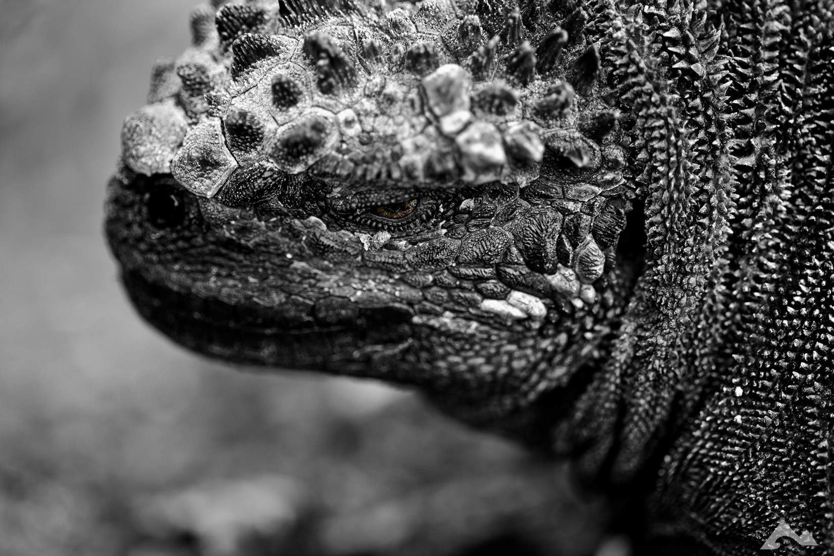
Underwater photography in Galapagos – Visiting the Galapagos was a childhood dream come true. Since I was a young boy, I had a dream of swimming in these distant waters of Ecuador and finally meeting a marine iguana. The experience was fantastical, challenging and humbling. The Galapagos is the birthplace of Darwinism for a reason! Shooting Underwater Photography in the Galapagos is exceptionally challenging. Galapagos is affected by seven currents, and at times they can be up to 5+ knots underwater. You usually take refuge by hanging on or behind boulders underwater. Photography is challenging when you are using manual focus underwater lenses as you only generally have one hand free for the camera and one for holding on to rocks.
Currents in Galapagos also move vertically. You can have 20 -30′ vertical exchanges in a matter of seconds due to down and up currents. Galapagos diving is only for those who are very experienced and have a sense of adventure. Several members in our dive group left their cameras behind to have both hands free to feel confident and safe underwater. I have a whole new respect for some of those fantastic underwater pictures you see from the Galapagos. The Galapagos is worth the visit; bring your adventurous spirit and your autofocus equipment.
SAFETY GEAR
You know this, but service your gear and ensure you go on 1-2 dives within a couple of weeks of your trip to ensure everything is working and you feel good with your diving skills. Also, GPS, Safety Sausages, Signal Tubes, Mirrors and Sea Snips are a must have. Also, you are probably bringing your camera so you will need a very strong and reliable tethering system
GALAPAGOS CURRENTS & DIVE CONDITIONS
First and foremost. Diving is a sport where you need to listen to yourself. Diving in places like the Galapagos is as much mentally and emotionally demanding as it is physically demanding. I consider myself to be in decent shape, an experienced diver with over 5000 dives and I lost 8 pounds during my week-long live-aboard in early 2010. This is not an article to scare divers. It is an article that I have written with additional content from Teresa Zubi to ensure you are ready when you go.


Vertical Currents & Eddies
Down current (vertical current down):
The Galapagos is an area with fast downward shifting water which is coming from the surface. There are two indicators for this type of current. Fish are not swimming horizontally but vertically, mostly down but also wildly up and in circles. At the same time, your bubbles start to go down instead up until the air is sucked down as soon as it leaves your mouth.
When large fish like mackerels are swept down past you, while trying to swim up again, it is time to find a coral head or an overhang to press firmly against or hide under. Because if not, as soon as the current reaches more than a knot you won’t be able to fin up against it and inflating your jacket won’t help you either!
Up current (vertical current up):
You don’t know how bad currents can be until you experience a strong up-currents. As every diver knows, to be swept up too fast is very dangerous (decompression sickness, lung damage) and should be avoided at all costs. It is scary if you ever experience it.
Eddies: Washing machine/roller coaster:
An eddy is the swirling of a fluid and the reverse current created when the fluid flows past an obstacle. The moving fluid creates a space devoid of downstream-flowing fluid on the downstream side of the object. Eddies happen when currents run down in small cuts or dips in rock faces. They usually shoot down and the current is pushed into a circular motion. Similar to a washing machine. You can quickly get disoriented, remember bubbles head to the surface.
OCEAN CURRENTS
An ocean current is a continuous, directed movement of ocean water generated by the forces acting upon this mean flow, such as breaking waves, wind, Coriolis force, temperature and salinity differences and tides caused by the gravitational pull of the Moon and the Sun. Depth contours, shoreline configurations and interaction with other currents influence a current’s direction and strength.
Galapagos Marine Ocean Currents
Humboldt Current
Predominate in the third quarter of the year the Humboldt Current runs up the west coast of South America from Antarctica. [This current is what brought penguins and fur seals to the Galapagos].
As the Humboldt Current moves through the islands during the 3rd and 4th quarter from June to November, it cools temperatures. The winds come from the southeast and create an inversion over the area. Low straight formed clouds cover the islands much of the day. A drizzle known as garua occurs in the highlands. The garua visibility is lower than in the warmer months. Though there is more frequent precipitation this time of year the light rain made it difficult for settlers to collect water during this season. This time of year is referred to as the dry season.
Water temperatures during the cooler months of August and September range from 60° to 65°F [16° to 19°C] in the western islands to around 78°F [25°C] near Darwin and Wolf at the far north of the archipelago. The average water temperature is 70°F [21°C]. From October to December the water temperature drops to the between 60° to 70°F [16° to 21°C] range.
These later months are a good time for green sea turtle sightings [during their mating season] and shark sightings are still high, but rays are seen less frequently.
Panama Current
In November as the Humboldt Current leaves the Galapagos the warm waters from the Panama Current come to take their place. These warm waters dominate the climate in the islands from January to May.
During these months the water temperatures rise to 70° to 80°F [21° to 27°C]. The air temperatures, which are no longer cooled create an inversion layer. The skies are clear and visibility is increased.
The marine life is excellent with many shark, ray and schooling fish sightings. This time of year the waters tend to have the best visibility and the best time of year for diving and snorkelling.
El Nino Current
Every 2 to 7 years the strong westward-blowing trade winds subside. These winds, which normally pull the warm waters to the west and allow the nutrient-rich Humboldt Current to reach the Galapagos, fail to leave the islands. Instead, the warm water slowly moves back eastward across the Pacific. The food chain is broken and the breeding cycle of many of the animals including;
Galapagos Penguins and Marine Iguanas, which feed off the upwelling are interrupted. Warmer water temperatures also cause an increase in the mortality rate of the young birds and animals. Plants, on the other hand, seem to thrive during El Nino years. Plants, which may not have flowered in years, will flower again due to the excess water.
Peruvians named this phenomenon El Nino, for the Christ child, because it first appears around Christmas. Major El Nino Currents occurred as recently as 1982 and 1998.


HOW TO ASSESS OCEAN CURRENT RATES
It is challenging to judge currents, but there are some indicators, which will tell a reasonable observer more or less the rate of current. Fish react according to how strong the current is. Some seek shelter; others thrive in a strong current. Observe small schooling fish like anthias or basslets and watch bigger fish like mackerels or triggerfish.
No current:
The small fish are swimming in every direction, in large schools distributed both vertically and horizontally over the reef.
Light current (to 1 knot):
The small fish are aligned, all facing up-current. If they are still in large, spread out schools, the current is around a half-knot. If the schools are low and wide, swimming close to the coral, the current is close to one knot. You can fin against this kind of current for a short time.
Medium current (1 to 2 knots):
The small fish are now hovering in a school spread out just barely above the coral and finning madly. A current of this strength begins to show in the behaviour of the larger fish as well. They face the current and tend to concentrate behind coral heads or in other lee areas (lee =away from the wind/current). Most fish will now swim against the current, so if you do a drift dive, schools of fish will come towards you. In this kind of current, it is already difficult to swim against.
Strong current (2 to 3 knots):
In this kind of strong current, the small fish are not seen, because they are all hiding among the branches of the coral. The big fish are gathered in lee areas, or very close to the bottom. On a drift dive in this kind of current you won’t be able to stop and fin against if you want to look at something close up – so enjoy the ride!
Powerful current (3 knots):
Now you won’t need the fish as an indicator anymore. You are either swept along on a speedy drift dive or hiding behind a coral head. If you move your head around and face the current full-on, your mask is fluttering and threatening to fly off, and your regulator begins to free-flow.
Too Much!!
Anything over 3 -4 knots is too strong, and this is very dangerous for a diver! In a matter of minutes, you can be kilometres away from the boat, and if the seas are big, then it will become increasingly tricky to sea a signal tube. This is when GPS devices are a good idea.
If you don’t hang on, use reef hooks or gecko dive, then the currents in the Galapagos will = very short dives. 3 knots = 5.4 km per hour, so you travel 2 km in 22 min.), or the current couldn’t have been much more than a knot (2 km per hour is 1.1 knot). An example of this was when we dove Darwin’s arch; we had to Gecko dive for the first 30 min. This starts with a negative (no air in your BCD) backwards roll off the zodiac a quick descent in the current to about 50′. Then you would do what I call upside down bouldering as you pull yourself along the reef and over to underwater cliff edges. You would hang out in these spots at around 80′ while looking out to see whale sharks and schooling hammerheads.
Then you would release and quickly shoot along the plateau (sandy bottom and reef between the arch and Darwin island.) I would often choose to descend into the sand and dig in for a while as Hammerheads would fly overhead, others would continue to ascend and do their safety stops. I would ascend over the plateau, but could see members who were next to me 5 – 8 minutes earlier would be at the far end of Darwin island. Almost 1km away. It is a lot of work for the surface crew and requires a lot of concentration from the divers. While surfacing, you want to ensure you keep clear of caves or eddies that might be present along Wolf and Darwin Island.
When we were in the Galapagos diving off of Darwin’s Arch, we figured we were in a 4-5 knot current. We had 16 members on our boat, and after our first dive, we only had eight members will to test the rest of the dives at Darwin that day.
This is a picture of the ocean currents that was created in 1943

GEOLOGY
The Galapagos Archipelago comprises 13 large islands, six small islands, 42 islets and several small rocks and pinnacles, which make up a total land surface of 8,000km2.
The Galapagos Islands, located on the equator about 1000km (600m) west of Ecuador, were never part of mainland South America. They are a group of submarine volcanoes that grew progressively from the ocean floor until they finally emerged above sea level about 4.5 million years ago and formed a group of islands. The islands have been added to, and new islands have been forming ever since. Each island is formed from a single volcano, except Isabela, which comprises six volcanoes strung together.
The Galapagos Islands is not formed at the junction of two or more tectonic plates, as are many of the world’s volcanoes. They occur within the Nazca Plate, and are interpreted to be the result of a ‘hot spot.’ A “hot spot” is a region of high thermic flux due to the presence of a magmatic plume ascending from the earth’ mantle. The rising magma pierces the oceanic crust in a weak part of the plate (e.g. where the plate is fracturing), and magma is extruded onto the seafloor. Another classic hot spot is responsible for the formation of the Hawaiian Islands.
The Galapagos Archipelago is a chain of islands. This is not the result of the movement of the hot spot, instead, the hot spot remains stationary and the Nazca plate drifts over it to the southeast (at a rate of about 3 inches, or approximately 6.5cm, per year), taking the older islands with it, while new islands form the to the Northwest. Thus the oldest island is Isla Espanola in the Southwest, while Fernandina and Isabela in the northwest are the youngest and most volcanically active.
Pahoehoe lava – with a ropey surface
Like the Hawaiian Islands, the Galapagos are basaltic in composition. Basalt has a relatively low viscosity and typically forms volcanoes with gently sloping flanks.
The submarine or seamount stage of growth is represented by basaltic pillow lavas, hyaloclastites (quenched fragmented lava), and, as the seamount approaches the surface, by coherent submarine lavas. Above sea level, shield volcanoes are composed of lava flows, with limited scoria fall and spatter deposits.
The Galapagos shields have gentle lower slopes that rise to steeper central slopes (34 degrees) and ultimately flatten off to form spectacular summit calderas between 3 and 9km in diameter, the most significant being on Sierra Negra. Calderas are large, broadly circular volcanic depressions that are usually formed by the collapse of the roof of a subsurface magma chamber. Collapse often occurs during or after the evacuation of the magma chamber by an eruption. An event of this type occurred, for example, on Volcan Fernandina in 1968, when the caldera floor subsided by 300m.
Galapagos shield volcano
The dome-like shape of the Galapagos shields has been described as an overturned soup plate, in comparison to the gently sloping overturned saucer-shape of the Hawaiian shields. Scientists have suggested that the presence of intrusive rocks (e.g. basalt dykes and sills injected into the lava pile)at a high level may account for their characteristic shape.
The Galapagos Islands are among the world’s most active volcanic areas today. There have been over 50 eruptions in the last 200 years, and many are recent for example; Fernandina had erupted on a regular basis, every 4-5 years since 1968, with the last eruption being in 1995 when lava flowed into the sea, also Volcan Cerro Azul on Isabella had erupted regularly over periods of approximately tens years since the 1950s (intervals were closer together before that), with the last eruption being only last year, when lava flowed down the south flank of the volcano.
CLIMATE
One of the things that make the Galapagos Islands so unique is its climate. Firstly the islands themselves are isolated and are surrounded by several hundred miles of the open ocean. Thus their climate is determined almost exclusively by ocean currents, which are themselves influenced by the trade winds that push them. The marine biota is also affected by these currents.
The Galapagos Islands are situated at a major intersection of several ocean currents, the cold Humboldt current (which predominantly influences the climate), the cold Cromwell current (also known as the Equatorial Countercurrent, which is responsible for much of the unique marine life around the Galapagos) and the warm Panama current. The intensity of these currents varies during the year, as the respective trade winds that blow them weaken. Thus two distinct seasons occur depending on which current is dominant at the time.
For most of the year, the Galapagos is cooled by the upwelling of the cold Peruvian oceanic and the Peruvian coastal currents (known collectively as the Humboldt current), which sweep northwards from the Antarctic, pushed by the Southeast trade winds. The Humboldt current has a mean temperature of 15 degrees centigrade. Upon reaching the Galapagos platform, the cold nutrient-rich waters surface from a depth of 100m. The cold waters cool the air above them, producing a temperature inversion. That is, instead of the air gradually cooling with increased elevation, as is the norm, the air at, and above the ocean surface is cooler than that above; thus a temperature inversion occurs.
Ocean currents affecting the Galapagos Islands
The inversion layer has several effects. Firstly it contains a high concentration of moisture droplets that have evaporated from the ocean. Since some Islands have volcanoes high enough to intercept the inversion layer this results in condensation of the moisture which produces a continuous mist at a high level – this is called the Garua and gives its name to the cool, dry season, which lasts from May to December. Although the Galapagos highlands are kept damp during this period, the lowlands and low-lying islands remain bone dry.
The cold Cromwell current, also known as the subequatorial Countercurrent, is also a significant influence on the Galapagos islands. It is the principal reason why the marine environment around the Galapagos islands is so unusual. The Cromwell current is a deep flow of oceanic waters originating in the western Pacific. It runs beneath the Equator in the opposite direction to the bulk westward movement of the surface waters, which form the South Equatorial Current. The Cromwell current has a temperature of only 13 degrees centigrade at its core. It runs thousands of miles along the depths of the ocean gathering nutrients which rain down from the surface layers above. When the current encounters the submarine Galapagos platform, it upwells to the west of Fernandina and Isabela Islands and dissipates towards the center of the archipelago.
When the Southeast trade winds slacken, usually around December the Humboldt current loses its driving power. The northeast trade winds become dominant, sweeping the warm, but nutrient poor, waters of the Panama current south. The waters around the Galapagos are warmed to about 27 degrees centigrade and as a result, the inversion layer breaks-up, allowing the tropical weather pattern to reassert itself. Cumulus clouds build up during the morning, and a downpour occurs most afternoons, this is known as the rainy or warm season and lasts from December to May.


El Niño Events
This is the normal state of affairs for the Galapagos Islands. Some years, however (every four to seven years) the south-east trades winds do not develop sufficiently to sweep the Humboldt current northwards, and the Panama current drastically warms the waters around the islands. This phenomenon is known as El Niño, named by the Spanish, meaning ‘the child’ because it typically begins around Christmas. On the positive side, it brings lots of rain and favours vegetation growth; however, it also has a drastic negative effect. Under normal circumstances, the upwelling of the cold Humboldt current brings nutrients to the surface, ensuring a plentiful supply of plankton for animals low down in the food chain, e.g., fish and squid. Without this occurrence, the food chain is broken at a critical point, and many larger animals such as the Galapagos fur seals, sea lions and marine birds such as Bobbies, Flightless cormorants and penguins starve to death as their food departs for deeper cooler waters.
Cold, nutrient-rich waters are warmed during El Niño events
In 1982-83 the Galapagos suffered the effects of an exceptional El Niño, which brought nine months of continuous rain to the Islands, very high humidity and sea surface temperatures of 30 degrees centigrade – and resulted in very high animal mortality. In 1997-98 the Galapagos suffered another drastic El Niño event, and many animals were again effected, for example, the populations some sea lions and boobies fell by as much as 50%. The Marine Iguanas also suffered even though they are vegetarian. The abnormally warm waters prevented the growth of the algae they feed on, and although they switched to alternative food in many cases, they were unable to digest it and starve to death with full bellies. A classic example of nature ‘bloody in tooth and claw’.


West Galapagos Islands
The Galapagos is an extremely sensitive and protected part of the world. Over the past decade, there have been numerous changes to live-aboard, land tour and diving permits. Also, most live-aboard companies are only booking agencies with boats holding their brand name. A lot of these boats are franchises. From time to time, boats will change ownership and be removed from fleets. When I went to the Galapagos, I booked almost three years in advance, and we were some of the last divers allowed to dive during a re-assessment phase in the middle of 2010.
Isabela and Fernandina
The western islands take you to the youngest of the Galapagos Islands – Fernandina and Isabela. These islands are still in the process of formation and are home to the only active volcanoes in the Galapagos Islands. Visiting the area, you’ll learn about how the islands were born of fire and how they developed over the years. Stark black lava fields cover much of these islands only pioneer plants such as cactus and mangroves that require little nutrients or soil survive.
Here near the western Galapagos Islands, the ocean has the most nutrients due to upwelling. The marine life is abundant, and the wildlife that lives on these islands is dependent on the sea. The western islands are the best place in the Galapagos Islands for whale and dolphin encounters. Much of the wildlife that lives in the western islands are endemic to Galapagos Islands. These species adapted to survive in the harsh conditions. Over 95% of the Galapagos Penguin population lives in the western Galapagos Islands, and this is the only area to see flightless cormorants.
Isabela is with 4’670km² the largest island in the Galapagos. Most of the diving is done around the north coast (Cape Marshall, Punta Albermarle, Punta Vicente Roca) and at Roca Redonda (on the trip north to Wolf and Darwin). On extended trips, Fernandina island is also visited, but diving in some dive sites is not permitted anymore. Puerto Villamil in the south of Isabela also offers some exciting dive sites around several small islands in the surrounding. The west of Isabela is directly in the path of the Cromwell current (see map), so there is a lot of upwelling cold water. Temperatures are around 20 to 24°C but can drop to 13 to 15°C (in El Niña years)! Galapagos Geology and Climate.
This area is especially interesting since several fishes are more abundant here than elsewhere in the Galapagos islands because of the cold water, such as the Galapagos horned shark, the Galapagos rock bass (Camotillo), the gold-rimmed surgeonfish, the harlequin wrasse or the sailfin grouper (Bacalao). Fernandina is very isolated and has endemic species seen nowhere else on the Galapagos, such as the flightless cormorant or – in the water -the endemic Galapagos Grunt (Orthopristis forbesi) and the White Salema (Xenichthys agassizi).
Isabela and Fernandina sit directly on the mantle hot spot and are geologically very active with seven large volcanoes. Fernandina is one massive shield volcano with a large caldera and many lava flows. On Isabela there have been at least 13 eruptions since 1911, five of them at Cerro Azul and just 1998 a kilometre long crack opened and fountains of lava erupted to several hundred meters height, and three eruptions at Santo Tomas (Sierra Negra – black mountain) volcano in the south and five of them at the Wolf volcano in the north.
Isabela is also interesting for its flora and fauna. The young island does not follow the vegetation zones of the other islands. The relatively new lava fields and surrounding soils have not developed the sufficient nutrients required to support the various life zones found on other islands. Another noticeable difference occurs on Volcan Wolf and Cerro Azul, these volcanoes loft above the cloud cover and is arid on top.
Isabela’s abundant animal, bird, and marine life are beyond compare. Isabela is home to more wild tortoises than all the other islands. Isabela’s large size and notable topography created barriers for the slow-moving tortoises; apparently, the creatures were unable to cross lava flows and other obstacles, causing several different sub-species of tortoises to develop. Today tortoises roam free in the calderas of Alcedo, Wolf, Cerro Azul, Darwin and Sierra Negra.
Alcedo Tortoises spend most of their lives wallowing in the mud at the volcano crater. The mud offers moisture, insulation and protects their exposed flesh from mosquitoes, ticks and other insects. The giant tortoises have a mediocre heat control system requiring them to seek the coolness of the mud during the heat of the day and the extra insulation during the cool of the night.
When tortoises reach 20 to 25 years of age, they become sexually active. Beginning approximately a month before the end of the rainy season the tortoises mate, after mating the females set out on a journey to lay their eggs. Alcedo females venture down to the sandy shores of Urbina Bay building nests in the sand. The female digs a hole with its hind legs approximately (30cm) deep. Once she is pleased with the hole, she deposits between 2 and 16 eggs then covers the eggs with a layer of mud and urine before starting her journey back up the mountain. Baby tortoise takes between 120 – 140 days to hatch usually happening between December and April.
On the west coast of Isabela the nutrient-rich Cromwell Current upwelling creating a feeding ground for fish, whales, dolphin and birds. These waters have long been known as the best place to see whales in the Galapagos. Some 16 species of whales have been identified in the area including humpbacks, sperms, sei, minkes and orcas. During the 19th century, whalers hunted in these waters until the giant creatures were near extinction. The steep cliffs of Tagus Cove bare the names of many of the whaling ships and whalers which hunted in these waters.
Birders will be delighted with the offerings of Isabela. Galapagos Penguins and flightless cormorants also feed on the Cromwell Current upwelling. These endemic birds nest along the coast of Isabela and neighbouring Fernandina. The mangrove finch, Galapagos Hawk, brown pelican, pink flamingo and blue heron are among the birds who make their home on Isabela.
Elizabeth Bay
Located on the west coast of Isabela, at the Perry Isthmus, Elizabeth Bay is a marine visitor site (no landings are permitted). As you visit Elizabeth Bay panga, Galapagos Hawks soar overhear, and schools of pompanos and dorados can be seen swimming underneath you. Your panga brings you to Las Marielas the small islets just outside the bay and home to the largest concentration of Galapagos penguins living in the islands. This is one of the island’s breeding site for penguins. The ride continues into a red mangrove cove. The panga passes through the red root and green leaf breeding ground for fish and sea turtles. Brown pelicans, flightless cormorants, spotted eagle rays, golden rays and sea lions are often seen.
Tagus Cove
Lying directly east of Fernandina on the west coast approximately 2/3’s of the way up Isabela is the narrow channel of Tagus Cove. Arriving here the boat will sail through the Bolivar Channel, these are the coldest most productive waters in the Galapagos, the upwelling of the Cromwell Current, where dolphins and whales are frequently seen. Tagus Cove, named for the British naval vessel that moored here in 1814, was used historically as an anchorage for pirates and whalers. One can still find the names of the ships carved into the rock above the landing (a practice now prohibited). The coves quiet waters make for an ideal panga ride beneath its sheltered cliffs, where blue-fitted boobies, brown noddies, pelicans and noddy terns make their nests, and flightless cormorants and penguins inhabit the lava ledges.
From the shore, a wooden stairway rises to the dusty trail passing through the paleo santo forests to reach the perfectly round saltwater crater, Darwin Lake. Continuing on the trail around the lake through a dry vegetation zone, and then climbs inland to a promontory formed by spatter cones. The site provides spectacular views back towards the anchorage in the bay, as well as Darwin Volcano and Wolf Volcano farther north.
Urbina Bay
Lying at the foot of Alcedo Volcano, south of Tagus Cove, is Urvina Bay (Urbina Bay) one of the best and the most recent example of geological uplift in the Galapagos. Uplift occurs when the molten materials beneath the surface shifts. In 1954 the shoreline was uplifted nearly 15 feet (4 meters). The coastline was driven 3/4 of a mile further out to sea, exposing giant coral heads and stranding marine organisms on what was now on shore. A Disney film crew visited the site shortly afterwards and discovered skeletons of sharks, sea turtles and lobsters unable to find the ocean from the rapidly rising land. Schools of fish were found stranded in newly formed tide pools. Boulder-sized coral heads can be seen near the area that once was the beach. The uplifting of Urbina Bay was followed by an eruption of Alcedo a few weeks later.
Seasonally Urvina Bay provides a nesting area for many of the Galapagos creatures. Female tortoises journey down from Alcedo to lay their eggs in the sand. Galapagos penguins, flightless cormorants and brown pelicans nest in the area as well.
The visit begins with a wet landing on the white sand beach. The difficulty of the route varies by season. The trail ranges from stark and easily passable during the dry season to mildly challenging requiring wading to pass during the rainy season. Visitors cross the uplifted region learning about this geological wonder. Then reach the sandy area that was once the beach. Shorter visits return to the landing point on the same path, while more extended visits continue past the coral heads and a new beach.
Other highlights of this site include marine iguanas and some of the largest land iguanas in the islands, and Galapagos Cotton an endemic plant, historians believe the Incas brought to the islands, while naturalist theorizes it floated across from Peru.
Punta Moreno
An interesting part to any tour located on the western shore of Isabela, Punta Moreno is often the first or last stopping point on the island (depending on the direction the boat is heading). Punta Moreno is a place where the forces of the Galapagos have joined to create a work of art. The tour starts with a panga ride along the beautiful rocky shores where Galapagos penguins and shorebirds are frequently seen. After a dry landing, the path traverses through jagged black lava rock. As the swirling black lava flow gave way to form craters, crystal tide pools formed-some surrounded by mangroves. This is a magnet for small blue lagoons, pink flamingos, blue herons, and Bahama pintail ducks. Brown pelican can be seen nesting in the green leaves of the mangroves. You can walk to the edge of the lava to look straight down on these pools including the occasional green sea turtle, white-tipped shark and puffer fish.
This idyllic setting has suffered from the presence of introduced species. Feral dogs in the area are known to attack sea Lions and marine iguanas.
Puta Albemarle
At Isabela’s remote northern tip reminisce of a US WWII radar baselines the shore. The rough seas and pounding surf make it difficult for visitors to do much more than see the water barrels left behind.
Those fortunate enough to go ashore at Punta Albemarle can see that the site is much more. It is the nesting site for flightless cormorants and home to a colony of the largest marine iguanas in the islands.
Punta Garcia
Located on the eastern coast, across the Isabela Channel from James Island. Previously the site was only accessible by panga; the park service now permits land visits. Arriving at Punta Garcia begins with a dry landing in some rough current causing the panga and passengers to get wet. This is the only visitor site on Isabela reachable without sailing around the west coast.
Darwin Volcano looms above this barren landscape covered with aa lava. Just above the shoreline flightless cormorants used to be seen breeding between March and September. The birds now seem to have deserted the site leaving an occasional brown pelican behind.
Sierra Negra Volcano
Located in the southern part of Isabela between the volcanoes Alcedo and Cerro Azul. Sierra Negra’s caldera at 6 miles x 5 miles is the largest in the Galapagos and the second largest in the world.
The journey up to the crater begins at Puerto Villamil. From the town of Villamil, you follow the road to the small village of Santo Tomas where if you have arranged to go via horseback – your horse will be waiting. Whether on foot or by horse the trip takes between 3 – 5 hours. The landscape along the way is quite lovely. Once on top, there are a series of fumaroles inside small craters. The view during the “rainy season” is quietly spectacular.
Roca Redonda
Roca Redonda is located off the northwest tip of Isabela Island, separated by about a 30km stretch of very deep water. This is the tip of a submarine shield volcano that rises nearly 3000m from the sea floor and emerges from the water as an island. The underwater area of this volcano is said to be about 18 kilometres wide. The island is about 300 meters high with steep cliffs and a flat top. Several lava flows can be observed on the island and in the shallow water, and there are various caves. Seabirds live here, for example, the swallow-tailed gulls (Larus furcatus). These gulls are endemic to the Galapagos and the world’s only night-feeding gull. It has unusually large eyes and feeds on squids that come to the surface, usually about a 15-30km distance from the nearest land.
This dive site is visited either on the way up to Wolf and Darwin in the north or as part of a tour around Isabela. The water temperatures are very low here, because of the cold Cromwell current. Diving can be challenging because of the strong currents, unpredictable down currents, eddies and the heavy surge. If conditions are not right, your dive guide might advise you against diving. Be prepared when diving in the Galapagos. Read this article to learn more
You dive around several underwater rocks and pinnacles always accompanied by sea lions. This is an excellent place to find schools of scalloped hammerheads, yellow tailed surgeonfishes, barracudas, jacks, Galapagos grunts and king angelfishes. Galapagos sharks and whitetips, mantas, and even the huge sunfish visit this remote place. With luck, you can also find seahorses among the rocks in the shallows.
A special attraction is on the Southeast Side of the island. There are several underwater fumaroles (steam vents) in the shallows (12 to 18m), and you can see gas bubbles rising to the surface which indicate that the volcano is probably still active. I have visited a place similar to this in Siau, Indonesia, where there were hot sand and so many bubbles, it looked like a curtain, and found, that some species of marine animals grow much more significant because of the abundance of some minerals. Anyway – it’s also just exciting to touch hot rocks below the water and swim among bubbles…
Northeast Isabela
Punta Albemarle lies on the very northern tip of Isabela. Rocky volcanic cliffs drop down to the ocean floor as almost vertical walls. You might see large animals like manta rays, marbled rays, hammerhead sharks and marine turtles, but also Chevron barracuda, snappers, yellowfin tuna, rainbow runners, wahoo and groupers. There are also a lot of smaller fishes like creole fishes, parrotfishes, scrawled filefishes, pacific boxfishes and tiger snake eels.
Cape Marshall (Puerto Egas) lies on the eastern side of Isabela Island. You dive were a huge lava stream from the Wolf volcano stopped flowing into the ocean. The lava breaks off abruptly and forms a very steep slope with boulders and lava ridges. Coral cover is sparse with some black corals. Depending on the prevalent current, you dive along either from north to south or vice versa.
This is a good place for mantas, mobula rays and eagle rays but also for the occasional shark, yellowfin tuna and sealion. We saw several huge mantas close by – one of the blacks on the top as well as on the belly – but the most impressive sight was the school of mobula, probably at least 50 animals, that we met several times. As we swam out into the blue, they were suddenly all around us, with quick flips they sped past the whole school, and engulfed us, mobulas in front, above, behind and on all sides! They stayed around, formed a more compact group again and let us swim along for a while. An eagle ray which also joined us only got a glimpse from us, we were so entranced from the mobula rays!
Isabela (Albemarle) West and South Side
Punta Vicente Roca lies at the northwestern point of Isabela close to the volcano Ecuador. There are two beautiful coves which lie on either side of the eroded remains of a volcanic cone. You start your dive on a shallow wall, that becomes a steep drop-off down to 50m. The wall is full of crevices and narrow shelves and is nicely covered with sponges and corals, and you can find nudibranchs, crabs, slipper lobsters. There are several fascinating species of fishes living here, the red-lipped batfish, frogfishes, seahorses, electric rays and the endemic camotillo. Here you can see schools of barracudas and salemas and even the occasional sunfish and marlin has been spotted here. Mostly drift diving. Night dives possible – good for crabs, shrimps and lobsters and other invertebrates.
Fernandina
The youngest of the Galapagos Islands, Fernandina is approximately 700,00 years old. It’s location to the west and on the far side of Isabela makes it one of the least visited islands.
It still is one of the most active (volcanically) since eruptions still may occur every few years, which changes the landscape and life on the island. In 1968 the caldera collapsed dropping 1000 feet in 2 weeks. Eruptions in 1995 occurred from a smaller volcano located on the southwest corner of the island.
This constant state of volcanic change gives Fernandina Island it’s unique feeling. Lacking the native plants and animals of the other islands visitors obtain the feeling of being at the end of the earth.
Fernandina is home to a large colony of marine iguanas, Galapagos Penguins and flightless cormorants.
Punta Espinoza
Located on the northeast part of Fernandina the visit begins with a dry landing. If the tide is right, it is possible to use a dock; otherwise, the landing is made on to volcanic rock and it can be slippery. The trail to the shore can be filled with interesting obstacles, including marine iguanas and mangrove branches. Once on shore, there are two paths:
From the left of the landing site, the trail leads into the lava fields. As the youngest of the islands, Fernandina allows visitors to view the recent volcanic activity.
The lava itself is very fragile and full of fissures, which can cause for tenuous walking conditions.
Plants are nearly devoid in this area; lava cactus seems to be one of the few plants able to survive. These small cacti live only a few years, growing in groups. The spines are yellow when young darkening with age and the flower is a creamy white visible only in the early mornings.
This Land’s End trail takes you to a barren patch of land with a few mangroves and abundant wildlife. Fernandina is home to the largest colony of marine iguanas. During the first half of the year, the iguanas nest here by burrowing small holes in the sand.
Following the trail near the tip of the point, a colony of sea lions can be seen. Male sea lions are incredibly territorial, and their barks warning off would-be-intruders are heard over the sound of the crashing surf.
Flightless cormorants nest in along this rocky area near the high water line, and recently Galapagos Penguins have been spotted nesting in the area.
East Galapagos Islands
The center islands of the Galapagos are surrounded by water that is not so deep as in the north or west. Most places are more protected and the water generally is somewhat warmer (21 to 26°C around Santa Cruz and slightly cooler around Santiago). Dive sites are very varied and can be combined with land trips to the different islands. There are nice reefs near Floreana (Devil’s Crown, Onslow island) and Bartolomé island.
Most of the scuba diving in this area is done in day trips from Puerto Ayora, where there are several dive operators with small, but fast boats. Your other choice is to go on a liveaboard trip which either gets you around the central and southern islands or to the north and western part of the Galapagos.
Santiago (San Salvador / James)
Also known as James and San Salvador the central location and numerous landing sites make Santiago a part of almost every Galapagos itinerary. A favorite island for pirates and whalers, Santiago has a long human history as well as some outstanding opportunities for wildlife viewing. Highlights of a visit include the fur seal grotto, pink flamingo lagoon as well as the chance to see Galapagos Hawks and vermilion fly catchers.
Once rich in vegetation, feral goats were released on the island in the 1880’s. The goats thrived in the lush environment eating everything in sight and their numbers grew to over 100,000.
Their presence has severely impacted the island’s flora and fauna. The national park service working toward eradication, have improved the situation. Still, it is not unusual for visitors to see goats or signs of their presence.
During the 1920’s and again in the 1960’s human impact again took its toll on Santiago. Near Puerto Egas salt mining operations were attempted. Great effort was put into extracting salt from the crater though little profit was made and the venture was abandoned. Equipment and building were left behind some still remaining on the island today.
Visitor sites are located on both the east and west sides of the island, making multiple visits likely on longer trips. Many cruises may stop here en route to Tower or include sites in conjunction with visiting Bartolome or Sombrero Chino.
Puerto Egas
A visit to Puerto Egas begins with a wet landing on the dark sand beaches of James Bay. The visit begins with a walk along the rocky coast giving visitors the opportunity to view some of the Galapagos Island’s best tide pools. Sponges, snails, hermit crabs, barnacles and fish including the endemic four-eyed blenny can be seen. The walk also presents visitors with a variety of shore birds, marine iguanas, sally light foot crabs and sea lions.
James Bay (Puerto Egas) has a large fur seal colony. Fur seals and sea lions are seen underwater on most dive sites. Here they are extremely playful, come close to the diver, play with you, literally swim hoops around you, going straight for your head and turning aside at the last possible moment. Then they hover close by and seem to imitate you by letting air out of their mouth, push you a little here and there and check out your fins. While the females come close, the males patrol more on the edge of the group and try to keep their females together. Fur seals and sea lions can also be seen while snorkeling. This is a interesting dive site because you can find some animals here that you usually only find in Isabela such as sea pens, horn sharks and sand anemones because the water is quite cold here. Also good for scorpionfishes, seahorses, iguanas, sea robins and moreys
There are two interesting excursions normally visited from Puerto Egas. The first is a short walk from the landing site brings visitors to the site of one of the Galapagos’ first entrepreneur endeavors. For decades salt was extracted from a local salt crater. The industry was abandoned in the 1950’s leaving behind a variety of rusted old machines and parts of buildings. The trail follows the path once used by wagon trains to the crater cone.
The steep trail is easy, but can often seem one of the hottest hikes in the islands. Feral goats prune the arid vegetation, which lines the trail. The goats feed on any leaf within reach leaving little left for the endemic island creatures. Bird lovers will be delighted with the opportunity to catch a glimpse of one of Darwins finch, the endemic Galapagos hawk, or the colourful vermillion flycatcher.
Finally reaching the crater rim presents an incredible vista. Looking into the crater you are able to see this extinct volcano whose floor has sunken below sea level. Saltwater seeps into the crater creating a small salt lake. The sun evaporates the water, leaving the salt that many have tried to mine without success.
Looking away from the crater are the older orange lava fields supporting vegetation including the palo santo trees and the younger desolate black lava fields.
The second excursion begins just a short distance beyond the tide pools is the fur seal grotto. Fur seals and sea lions can be seen swimming in the rocky lava ringed pools. This may be the only opportunity visitors have to see and swim with fur seals.
Fur seals were once hunted to near extinction for their coats. The Galapagos Fur Seal is the smallest of the fur seals found in the southern hemisphere, now compare in numbers with the sea lions. During the day they hide from the hot equatorial sun in shelves or caves of the rocky lava cliffs. At night they feed on squid and fish avoiding the sharks, which are their natural predator.
The crystal clear water, volcanic bridges, fur seals and sea lions make this a magnificent place for swimming and snorkelling.
Buccaneer’s Cove
Less than an hour north of Puerto Egas, Buccaneers Cove served as a safe haven for pirates, sailors and whalers during the 18th and 19th century. Anchoring in the protected bay they were able to make much-needed repairs to their ships while other men went ashore to stock up on salt, tortoises, fresh water and firewood. Several years ago ceramic jars were found at the bottom of the bay, the disregarded cargo of some mariner from years gone by. Inside the jars were supplies of wine and marmalade.
Albany Rock is a small crescent-shaped island near Buccaneers Cove. You dive at a protected cove with little current. There is a sloping rock wall covered with sea fans and yellow black coral and large boulders, rocks, and underwater pinnacles with many crevices. Marine turtles, barracudas, golden and spotted eagle rays and Galapagos shark have been seen here and on the rocks live groupers like the common flag cabrillas (Epinephelus labriformes) and on the sandy plateau red lipped batfishes have been found
Few boats stop at Buccaneers Cove today. Though many cruises by at a slow speed giving visitors the opportunity to view the steep cliffs made of tuff formations and the dark reddish-purple sand beach. This dramatic landscape is made all the more impressive by the hundreds of seabirds perched atop the cliffs. Two of the more recognizable rock formations are known as the “monk” and “elephant rock”. A large population of feral goats now frequents Buccaneers Cove and this portion of Santiago. The National Park Service has fenced off part of the area to protect the native vegetation from the destructive eating habits of this introduced species.
A wet landing on the large coffee-coloured sand beach is just north of the prized fresh water supply that once attracted pirates and whalers.
Espumilla Beach
Visitors who now come to Espumilla Beach come in search of birds rather than water. A short walk inland takes visitors through a mangrove forest normally inhabited by the common stilt. Sea turtles also visit these mangroves to nest. Beyond the mangroves is a brackish lagoon where flocks of pink flamingos and white-cheeked pintails can be seen.
The trail makes a loop heading over a knob into a sparsely forested area then back to the beach. Along the way, those with a watchful eye may spot a variety of Darwin finches or a vermilion flycatcher. Once back at the beach visitors may have the chance to swim or snorkel time permitting.
Sullivan Bay
In the early 1900’s the volcano on Santiago erupted, lava flowed eastward towards Bartolome. Edges of the lava field advance in tongues, hot magma raced ahead, flowing around and eventually engulfing any obstacles in its way. The extreme heat created by the flow would cause obstacles like trees to evaporate, leaving behind only an imprint of the life which once existed.
The Sullivan Bay lava field is a variety of interesting patterns. The shapes and textures of trees, which once existed there and hornitos caused when pockets of gas or water trapped under the lava exploded. The Sullivan Bay lava is known a pahoehoe (Hawaiian for rope). This thin-skinned lava’s molten material cools down after an eruption causing the surface materials to buckle creating a rope-like appearance. Panoehoe lava is rare to the rest of the world but is common to the volcanoes of Hawaii and the Galapagos Islands.
In the nearly 100 years since the Sullivan Bay flow, only a few plants have managed to take root in this harsh environment. The low-lying mollugo is commonly the first plant to emerge from a bare lava field. Together with the lava cactus (brachycereus) found here these plants are evidence of life returning to Sullivan Bay.
The walk takes approximately an hour to an hour and a half. Returning to the shoreline black and white oystercatchers can be seen fishing for crabs and mollusks in the tide pools.
Cousins Rock
Cousin’s Rock is a well-known dive site and is situated off the east coast of Santiago (north of Bartolome). This is one of my favourite dive sites, mostly because of the combination of nicely covered rocks and the possibility to see large animals as well. The rock has a triangular shape and rises about 10m out of the water. Underwater it is steep on the northern and western side and sloping on the eastern side. In the south lies a large rock separated by a narrow channel from the island.
We started on the steep wall and basically just jumped right into an enormous school of black striped salema (Xenocys jessiae). It was so enormous, that when we swam into the school we were completely surrounded by fish, it actually became dark and even for our bubbles, the fish wouldn’t budge much. I stayed still and stopped breathing and the fish closed in and nearly touched me.
You dive on a series of ledges made up of many layers of volcanic rock and overhangs alternating with steep slopes and walls of black coral. The wall and slope are nicely covered with black corals, small hard corals, sea fans, hydroid bushes and red sponges. Because of the many ledges and overhangs, small animals can hide well – you will find different species of hawkfish (Oxycirrhites typus, Cirrhitichthys oxyphalus, Cirrhitus rivulatus), nudibranchs, seahorses and even frogfishes. Out in the blue, you can see mobula rays, mantas and sharks (white tipped reef sharks, hammerhead sharks). Cousin’s Rock is also known for the large groups of spotted eagle rays seen here and there are a lot of sea lions which like to chase the salemas.
Around the southern part, there is also a nice area with a large rock separated from the mainland by a small channel. The rock has a huge longish overhang where black coral bushes grow. There can be current here, so it is always not possible to swim around it. Just go back and cross over through the small channel. Google Earth pictures: Cousin’s Rock
Rabida Island (Jervis)
Rabida is a small island to the southwest of Santiago with interesting reddish lava. There is a large saltwater lagoon with flamingos and a colony of pelicans. Isla Rabida is actually the best place to see breeding pelicans. You dive on the western side of the island (West Cove) and the north (North Point), where it drops down to over 30m. There is a large colony of sea lions and you can of course also encounter them underwater. Eagle rays, white-tip and Galapagos sharks, schools of salema and sea turtles are also seen here. The place is also good for observing marine iguanas feeding underwater
Bartolomé Island
his small island located just off Sullivan Bay east of Santiago. Bartolome, a desolate island with few plants is the most visited and most photographed island in the Galapagos. The island consists of an extinct volcano and a variety of red, orange, green, and glistening black volcanic formations.
The best known of the island’s features is the tuff cone known as Pinnacle Rock. This large black partially eroded lava formation was created when magma expelled from the volcano reached the sea. When the seawaters cooled the hot lava it caused an explosion. The exploded particles eventually fasten together forming a rock composed of thin layers.
Bartolome’s Pinnacle Rock has become one of the best recognized and most photographed sights in the islands. A prominent sight it was used as a target for US airmen during WWII. Lying beside the Pinnacle Rock are twin half moon shaped beaches.
The northern beach is a popular snorkelling site where visitors have the opportunity to swim with fish, sea lions and Galapagos Penguins. Much larger animals can be found near the southern beach including stingrays, spotted eagle rays, white-tipped sharks, and black-tipped sharks.
Little vegetation grows in this barren place. Mangroves border the beach and the small shrub tiguilia grows in the volcanic sands. The seeds and tiny white flowers of the chamaesycae provide food for the island’s finch. These plants are common to arid regions and are able to survive in these harsh volcanic conditions.
Seasonally Bartolome is the mating and nesting site for the green sea turtles. Very little was once known of these enchanting creatures of the sea. They lived secretive lives only surfacing to breathe. In recent years, sea turtles have been the subjects of a variety of international studies.
The Pacific green sea turtle frequents the Galapagos Islands mating in the waters and laying eggs in the sands of the beaches. Green sea turtles do not mate for life or form bonds with their mates. Both the males and females of the species have many partners each season. Peak mating occurs between November and January.
Females come ashore at night during high tide to lay more than 80 eggs at a time. The female may lay eggs 8 times per season. The female comes ashore and digs a pit with her flippers near the high water mark. After laying the eggs she covers them with sand before returning to the sea. The process takes 3 to 4 hours.
The temperature of the incubation determines the sex of the young turtles. Eggs incubated at 82ºF will be males and those incubated at 90ºF will become females. The eggs hatch in approximately 2 months. Very few of the hatchlings survive their first year of life. Eggs are vulnerable to pigs and goats, as well as the natural predator the trox suberosus beetle. Seabirds prey on the young turtles making their way from their nests to the sea. Once in the water orcas, sharks and crabs feed on the turtles. With the high mortality rate and disappearing nesting grounds around the world green sea turtles are now an endangered species and the Galapagos breeding grounds is an important area for the preservation of these creatures.
Summit Trail
Begins with a rock and concrete pathway. The walk continues through volcanic sand, which can be slow to cross. Once through the sand, the steep ascent continues up a wooden stairway. From landing to top the walk takes approximately 30 to 40 minutes.
The volcanic landscape on the journey up seems barren except for the lava lizards scurrying about. Further up volcanic spatter cones with deep red, gleaming blacks and intense greens can be seen on both sides of the trail. The spatter cones and lava tubes give the feeling that you are hiking on the moon rather than an island in the Pacific.
Arriving at the top you are treated to one of the great panoramic views of the Galapagos. To the distance, the islands of Santiago, Santa Cruz, Baltra, North Seymour, Rabida as well as a number of rocks and small inlets can be seen. The islands vary in colour from a bright orange to blacks and greens. The turquoise waters and white shores add to the incredible scene. The eroded pinnacle rock stands at the end of the island posing for pictures.
It’s easy to see why this is one of the most popular photographic spots in all the islands.
Down below you will find the jutting Pinnacle Rock. You can dive or snorkel around this rock but also at the East Point. Already close to the beach, you will find sea anemones, sea urchins and I even saw an octopus while snorkelling in the northern bay. While diving you will find morays and schools of the Panamic sergeant major (Abudefduf troschelii – Fishbase) and the Bullseye puffer (Sphoeroides annulatus – Fishbase) on the walls, slopes, overhangs and around the caverns and crevices
Baltra
During World War II, Baltra was established as a US Air Force Base. Crews stationed at Baltra patrolled the Pacific for enemy submarines and protected the mouth of the Panama Canal. After the war, the facilities were given to the government of Ecuador. Today the island continues as an official military base.
Until 1986, Baltra was the only airport serving the Galapagos. Now one of two airports, those passengers arriving on Tame will land here. Upon arrival passengers must show their passport, INGALA Visitor Control Card and pay their Galapagos Park Fees (or the receipt of paid park fees) at the kiosk. Their hand luggage will then be inspected to ensure no foreign plants or animals are being imported.
Once these formalities are completed arriving visitors on cruises or pre-arranged tours are the meeting by their naturalist-guide or other crewmember holding a sign with the name of the boat. A short bus ride from the airport is the harbour where the boats wait for passengers to begin their tours. Baltra does not have any visitor sites.
Diving Around Baltra (South Seymour)
On Baltra is the main airport of the Galapagos, where flights from Ecuador mainland land. There are two islands north of Baltra, the small island Mosquera and the larger North Seymour with narrow channels separating them. This area offers superb diving (if the visibility is fine). Google Earth pictures: Baltra, Mosquera, Seymour
North Seymour
North Seymore: We did several dives on the northeastern part of Seymore, some starting just at the corner, some a bit more south. You dive on a rocky slope and end up in the shallower area close to the island. Jacks, manta rays, eagle rays, marble rays, stingrays and even hammerhead sharks and marlins have been seen here. There are also lots of reef fishes like Yellowtail grunts and blue-striped snappers (rayado) and salemas in schools. Since there are a lot of fish here, you can often observe birds like boobies diving into the water from above and swimming down to catch them and of course, there are also sea lions here.
Seymour Channel (to the south) can be an excellent dive site. The area is not very deep (about 20m) but sometimes there is quite a lot of current. You start from the eastern corner and following the major currents, you dive relatively fast over the rock plateau. Galapagos sharks cruise around and there are fish everywhere. There is a large sandy area at 15m with a colony of endemicgarden eels and white tipped reef sharks sleeping. You finish the dive either over this sandy area or you cruise along the slope of Seymore and end up north of the beach.
Mosquera
Mosquera is a large sandbank which lies north to south on a shallow area between Baltra and Seymore. There are two dive sites, West Beach and East Mosquera. Check dives are done here frequently because it lies close to Baltra.
East Mosquera: You start in the southeast corner and then go to the north. The eastern side forms a vertical wall with large boulders, the top is around 15 to 22 meters. You start your dive on a slope with boulders which at some places gives way to a mini wall and then reach a drop off where you usually find schools of grunts and snappers. The current comes from the east most of the time and can be quite strong in the channels north and south of Mosquera.
West Beach: There is a large colony of sea lions on the western sandbar.
Daphne island (Mayor and Minor)
Daphne Mayor: Here you dive in the south on a flat slope with large rocks between. It is worth to go close to the island on the last part of the dive, because there are areas with corals and with sea urchins, sea stars and everything is covered with cardinal fishes. We saw manta rays, green turtles, Almaco Jacks, sea lions, yellowtail grunts, large flag cabrilla and lots of blue-striped snappers. Sometimes sharks and eagle rays are also seen here. Google Earth pictures: Daphne
Daphne Minor: You can dive around the smaller of the two islands in one dive, especially if the currents help you part of the way. This is mostly wall diving, though there is a shallower plateau where you can make your safety stop. The walls are nicely covered with black corals and Gorgonians. A lot of small fish hiding there, marine turtles and sea lions join you and Gringos (Creole fish) school close to the rocks.
Piedra Ahogada (Drowned Rock): I heard, that this is a place, that pieces of machinery and small lead bombshells are lying around, probably from the U.S. Air Force which had a base on the Galapagos during World War II. It is said that this rock was much larger before it was used for target practice by the U.S. Air Force. Close to Daphne there is a dive site Tiburon Arecho (Horny Shark) which is a seamount that peaks at about 16m.
Santa Cruz (Indefatigable)
Located near the center of the archipelago, Santa Cruz is the center of tourism in the Galapagos. Its close proximity to Baltra airport makes the island readily accessible. Puerto Ayora the largest settlement in the Galapagos is the homeport to many yachts, as well as home to the Galapagos National Park and the Charles Darwin Research Station making it included as part of most cruise itineraries.
Santa Cruz’s human development began in the 20th century, between WWI and WWII settlers from the United States and Europe moved to the area. Santa Cruz made a perfect destination. A large island with a variety of geology, wildlife and vegetation, all of the Galapagos life zones are present on Santa Cruz. The villages of Bellavista and Santa Rosa were established in the highland’s humid zone. This region made prime farmland for the new immigrants who planted avocados, coffee, sugarcane, bananas, oranges, lemons, and farmed cattle.
Though the presence of humans and introduced animals has affected Santa Cruz, day trips from Puerto Ayora offer visitors many interesting sites.
Wild Galapagos Tortoises roam free crashing through the mist covered guayabillo, pega pega, and grasses of the humid zone. Flycatchers, Darwins finches and owl fill the scalesia forests near Los Gremlos. Almost every bird found in the archipelago has been seen within the many life zones on Santa Cruz.
The coastal region offers spectacular scenery. On the north shore of the island, accessible only by sea is an extensive mangrove lagoon called Caleta Tortuga Negra (Black Turtle Cove). Here among the mangroves turtle enjoy swimming in the calm waters, peaking their heads above the surface while fish, rays and small sharks circle below. A land iguana colony makes the northern Conway Bay their home. Sea lions cover Eden Island and almost every beach on Santa Cruz has their share of marine iguanas. Puerto Ayora along the southern shore is lined with cactus, marine iguanas, pelicans and boobies co-existing with tourist boats, restaurants, small hotels and houses.
Gordon’s Rock
Gordon’s Rocks (Roca Gordon) is said to be one of the best dive sites around Santa Cruz. The rocks lie a short distance north of the Plazas islands off the east coast of Santa Cruz. You dive in remnants of an old crater about 100m across. There are two large crescent-shaped rocks on the north and south (the rim), and a smaller rock with a channel and 3 underwater pinnacles in the west. In the middle of the area lies another pinnacle jutting up to about 17m. You can dive on all sides of the crater, both inside (sandy area) and out (vertical walls, very deep). Currents can be very strong here, the local name for the dive site is La Lavadora (washing machine). Since there are often heavy currents, eddies and down currents, swells and surge (especially inside the caldera) and the water is deep, this dive site is not for beginners.
We did several dives here and depending on the current we started the dive either along the wall or with a visit to the pinnacle in the middle. This pinnacle is beautifully covered with black corals. At the top are large clouds of endemic blacktip cardinalfishes (Apogon atradorsatus) covering everything. After you take a good look around you should start towards the three pinnacles in the northwest which connect the rocks underwater. They jet up to nearly the surface (6-2m) with deeper channels (15m) between. There is always some current and swell here, but it is easy to shelter on the lee side. Channels, crannies and cracks run down the rock, good places to see stingrays and sleeping reef sharks. On our dives we literally swam in fish soup, sometimes you felt like you had to push the fish away! You can also dive on the outer side of the rock, here it drops nearly vertically down to several hundred meters. There is a good chance for schools of hammerheads, whitetips and Galapagos sharks, amberjacks and pompano, eagle rays and golden cow rays, marlins and green turtles. This is also a good place to observe fur seals underwater.
Check out all the dive operators first, before you choose one. Some have relatively slow boats, some have better equipment than others. All dive sites are within easy reach of Puerto Ayora, the dive sites in the sheltered bay are also good for beginners and since they lie close to Puerto Ayora, they are very convenient for the dive operators. These dive sites are interesting, but there are better dive sites further north (for example Gordon Rock). The visibility there is also better than in the Bay itself. Outside of the bay, there can be strong currents, but there is a better chance to see sharks and other large pelagic fishes. Google Earth pictures: Puerto Ayora
Coamaño Island (Caamaño)
Is a small island just outside the bay. An easy dive. Sea lions join you as soon as you enter the water. There are also marine iguanas and tropical fishes.
Punta Estrada (Sea Turtle Canyon) is a point to the west of Academy Bay. Waves and currents are quite moderate here. You can see stingrays, marine iguanas feeding, sea lions, green sea turtles, golden rays, whitetip reef sharks. If you go to the east side of the point where a channel leads towards the mangroves you might also see pelicans which dive into the shallow waters there.
El Bajo Solmar, a nice dive site which lies in the south of the Academy bay. A bajo (Spanish for low) is the name for a submerged shoal. Around these places usually a lot of fish gather. You might find whitetip sharks, morays, eagle rays, stingrays and turtles.
Punta Nuñez Cliffs lie to the east of Academy Bay. I read it is wall diving and there is even a cave.
Nameless Rock (Isla Sin Nombre)
Nameless Rock lies to the west of Santa Cruz towards Pinzon, it is actually only a single large rock! It is a difficult dive on a steep wall with strong currents, down currents and surges. It is worth it, though, you might see Galápagos sharks, schools of pelagic fish, turtles and rays and there are sponges and small corals on the rocks. Only for experienced divers.
Guy Fawkes Island
The Guy Fawkes island is two crescent-shaped islands and two small rocks and lie to the northwest of the coast of Santa Cruz. Diving here is easy with not much current.
Pinzon (Duncan)
Isla Pinzon lies on the northwest side of Santa Cruz. The dive sites here are not so well known, because the island is visited infrequently. Currents can be a bit tricky and the dive sites are quite deep. There is an underwater plateau where you can find eagle rays, mantas, marine turtles, eels, seahorses and lobsters. In the shallow area near the tower rocks, you might also find horn sharks and red-lipped batfishes (Ogcocephalus darwini).
Santa Fé (Barrington)
There are three dive sites around Santa Fe island, the Lagoon, La Botella and the Caves (a cavern with a tunnel).
La Botella: The dive site lies on the west of Santa Fé close to a sandy bay where you can anchor. This is a very easy dive, no current at all, so the dive center we dived with traditionally goes there on Sunday mornings – so if the guests still have a hangover from Saturday night they can still manage this dive! You dive along a slope over boulders with black coral bushes. We saw a couple seals and rays and a large school of yellowtail surgeonfishes (Prionurus laticlavius). There are also small nudibranchs (Tambja mullineri) and hawkfishes and small colourful gobies are found between the rocks.
North Galapagos Islands
The north of the Galapagos is practically unknown to most visitors to the Galapagos, but Wolf (Wenman) and Darwin (Culpepper), two small and remote islands that can only be reached by liveaboard vessel, are a favourite destination for divers.
Wolf and Darwin, are located 186 km and 229km, respectively northwest of the northern tip of Isabela, so most liveaboard operators only come here on their 7 to 10-day tours and then stay one or two nights. Each island is the eroded top of a volcano, that rises from about 1100m below. Both are part of an elongate volcanic ridge, the Wolf-Darwin Lineament and not of the Galapagos plateau. Wolf’s lava was dated at about 400’000 years old, Darwin’s lava from 900’000 to 1.6 million years old, so they are younger than the islands in the rest of the archipelago.
Only seabirds live on the two small islets, for example, red-footed boobies. Red-footed boobies fish well out at sea, so they are seldom seen while diving. An interesting inhabitant is the sharp-beaked vampire finch (Geospiza difficilis / Deutsch: Spitzschnabel Grundfinken) on Wolf, who has the habit of pecking into the backs of boobies and ingesting blood from them. This feeding habit has probably developed in response to a relative paucity of food and moisture. It feeds on bird lice found in the feathers of the bobbies. They are also known to roll booby eggs out of the nest to break them and then consume the contents. Because of the remoteness, it is also interesting, that a species of endemic geckos have been found on Wolf.
The trip to reach the islands is also very interesting. Whales and dolphins can be seen on the way and frigate birds are flying along with the boat. At night swallow-tailed gulls (Larus furcatus) accompany you. These gulls are endemic to the Galapagos and the world’s only night-feeding gull. It has unusually large eyes and feeds on squids that come to the surface and usually flies out to about 15-30km distance from the nearest land.
(1) Darwin (Culpepper) :
Darwin is the northernmost island and about 4 hours or more by boat from Wolf. Darwin is 165m high, with vertical walls and a huge rock arch in the east. There is no possibility to visit the island. This dive area is not very protected, so dive conditions can be rough with waves, surge and changing currents. The currents are normally from the southeast and split right in front of the Rock Arch but also occasionally from the north. Not for beginners! The cold Humboldt current has little effect so far north, so the water is warmer by a few degrees (Dec – April: 24°C – 27°C and May – Nov: 22°C – 25°C ) so there are different corals here than around other islands, though also not very abundant. See Galapagos weather information.
Named for the island’s most famous visitor Darwin it is 4 hours north of Wolf. As the furthest north of the islands, the Humboldt Current has little effect here and the waters are warmer than in the south as such there are more corals here than the other islands. There are only a couple dive sites located southeast and northeast of the arch. Darwin is about quality rather than quantity and can be overwhelming and those returning on board are in awe of this magnificent area.
Beginning with the dolphin’s escort to your dive site, it is easy to see why this is the best site in Galapagos. Darwin’s Arch sits just above the surface on an underwater plateau. The steep barnacle covered walls drop off to the deeper ocean. Entering the water it is thick with hammerheads. At times there are so many you can’t count them all. As they swim over the reef you can reach out and touch them, however easily startled by divers bubbles they will quickly change direction and spook everything around them. On the ridge side, there are large schools of fish including creolefish, rainbow chub, bigeye jacks, moorish idols, mackerels, blue and gold snappers, Mexican hogfish, cornetfish, trumpetfish, parrotfish as well as Panamic green morays, turtles, flounders and octopuses. From June to November there is a very good chance to see whale sharks here – as well as tiger sharks, marlins and whales have been spotted.
Darwin’s Arch
(Rock Arch and Underwater Rock): On the east of the island there is an underwater plateau where a prominent rock arch rises. This is the main dive site in Darwin. Depending on the currents you start either from the south and go north or vice versa. Usually, part of the dive is spent over the sandy areas where the hammerhead sharks swim over in small groups. They come here to get cleaned by the Kings’s angelfish (Holocanthus passer). These angelfishes rise in small groups and start picking at the hammerhead sharks, thus getting rid of their parasites. The angelfishes also clean the eat skin parasites off the jacks that venture close. Large schools of gringos also gather here, mixed with mackerels, snappers, rainbow runners. Tunas and Jacks are hunting and the fish schools suddenly swerve to the side and form a tighter ball or walls, when these fish appear.
Channel Dive Site
Is covered with large rocks where you can hang on. It can be an advantage to bring a reef hook to this place. If carefully attached on the rock (not the corals!) it is much better than hanging on with your hands. Everywhere are fat morey eels (mostly fine spotted morey eel, Gymnothorax dovii) lying around. They don’t even hide like they do in tropical waters. Turtles (green turtle Chelonia mydas and hawksbill turtle Eretmochelys imbricata) swimming by lazily. Mexican hogfish, Moorish idols, coronet fish, trumpetfish, parrotfish, scorpionfishes are found here and in the rubble on the bottom live flounders and octopuses.
On each dive, you also should go out into the blue. Sometimes you have to wait around a bit, but on each of our dives we saw something interesting – dolphins coming down from the surface to take a look at us or play, yellowfin tunas in groups, a whale shark slowly passing by, large schools of hammerheads consisting of hundreds of animals swimming slowly along and Galapagos sharks coming in fast, swerving and disappearing again. To finish the dive you usually make a safety stop in the blue, but all the time watching out for other interesting animals cruising by!
Tower Rock
(small rock in the west if the island) and the Channel (between the Arch and the island), you might also encounter Galapagos sharks, silky sharks, dolphins, yellowfin tuna, bigeye jacks, mobula rays, eagle rays, golden cow rays and mantas. From June to October, there is a very good chance to see whale sharks. I heard, there are even sometimes tiger sharks, marlins and whales.
Wolf (Wenman)
A 14-hour overnight voyage brings you to Wolf Island. Exposed to waves, surges, strong shifting currents Wolf is for experienced divers only. With a number of protected anchorages a variety of dive sites and drift dives with large animals it’s no wonder this area has topped the list of favourite sites. Due to the warmer waters here you will find many fish found nowhere else including white mouth and zebra morays, trumpetfish, cornetfish, schools of jacks, rainbow runners, barracudas, tuna, bigeye jacks, blue-spotted jacks, wahoo, bacalao, salemas, yellowfin surgeonfish and marine turtles. Large pelagic fishes like whale sharks, Galapagos sharks, black-blotched stingrays, spotted eagle rays have also been seen here. Hammerheads swim in a never-ending parade across the reef as from the shallower waters towards the deep.
Depending on conditions Wolf offers excellent night dives. This is a great time for macros as you’ll get very close-up to lobsters, puffers, creolefish and some unusual crabs and anemones and the red-lipped batfish.
The diving is excellent here at all times of the year. This is one of the best places to see hammerhead sharks, whale sharks, mantas and eagle rays. The schools of hammerheads are common here all year long, whale sharks tend to congregate at Darwin from the middle of June until October and occasionally to the middle of December. Since the conditions can be rough for scuba diving and you are far away from any help, this is only for experienced divers.
Landslide
(Wall): The rocky cliffs drop steeply to below the ocean’s surface, part of the wall has slid down and large boulders form a nice rocky slope that bottoms out around 50m. Tube corals and small sponges and barnacles grow here. In the crevices morey eels live (fine spotted morey eel, Gymnothorax dovii and zebra morey Gymnomureaena zebra), they are really quite large and fat und frequently hunt outside.
This dive site is mostly known for the hammerhead sharks that gather here in large groups. There are also Galapagos sharks to be seen, eagle rays and turtles. On the dive site next to it – Shark Bay – we saw a wall of hammerheads out in the blue, all swimming in the same direction and on the shallower parts smaller groups of seven or twelve were seen swimming over the rocks to get cleaned. Schools of gringos and bluestriped chubs darken the water and tunas, rainbowrunners and mackerels dart between.
Pinaculos
(pinnacle) you mostly do a drift dive, but there are several swim-throughs and a cave and you can make your safety stop at the pinnacle. You can also dive at Hat Island and the Rock, although in the south there usually is a strong surge, which makes it difficult to surface.
You anchor in the sheltered to the west, the Anchorage (10). This place is known for the redlipped batfish (Ogcocephalus darwini), a strange looking bottom dwelling fish related to frogfishes. It walks and hops about mostly on sand and rubble, seen mostly at night.
Genovesa (Tower)
Genovesa is known more often by its English name of Tower and lies north of the equator. Genevosa is the remains of an extinct volcano that is open to the sea on the south side. The caldera of the volcano forms a cove, the Darwin Bay, which is sheltered by high cliffs. The island is very dry and flat and mostly inhabited by birds. There are large colonies of red-footed and Nazca boobies. The water can be warmer than at the central islands, thanks to the Panama current. Darwin Bay : It is possible to either dive along the inner wall or go to the outer wall, which is less protected. Another possibility is to dive from the outside of the volcano through the channel into the caldera. You might see groupers, jacks and barracuda, eagle rays, tunas and schools of smaller fish and sometimes mantas or hammerheads. Genovesa Geology – Genovesa (Global Volcanism Program) / Picture = Galapagos Hawk (Buteo galapagoensis)
Marchena (Bindloe)
Marchena’s 343m high shield volcano has been very active with an eruption in 1991, so about three-quarters of the island are covered with black lava and there are several fumaroles (steam vents). It is very dry and hot here. Except for diving it is seldom visited, it is not on the main route for liveaboards. You dive at Punta Espejo. Underwater you might see cow-nosed rays, turtles, schooling hammerheads and schools of blue-striped snappers, grunts, surgeonfishes, spotted moray eels and scorpionfishes. In the shallow water, you might find red-lipped batfishes. Best time to dive here seems to be the warm season, during the garua-season visibility is not very good.
Pinta (Abigdon)
Pinta is usually not on the itinerary of liveaboard excursions since there are no land tours. It is best known as the original home of Lonesome George, the land tortoise who used to live here
Galapagos Marine Life
Galapagos species – In the pages about the Galapagos islands, the word “endemic” is often used to describe a species that only occurs on these islands. Endemic animals or plants are restricted to a particular geographic region and found nowhere else in the world. Endemism usually occurs in areas that are isolated in some way. Since the Galapagos were never connected to the mainland which lies 960km away, all species had to reach the islands either by swimming (fish, sea lions etc.), by flying (birds, insects etc.) or on rafts (land animals, mammals, reptiles etc.). Once here they evolved and occupied different ecological niches. The endemic species in the Galapagos are specially adapted to the harsh conditions on the archipelago like the scarcity of fresh water, the availability of only certain food and the dark volcanic rocks.
Conditions for marine animals
Marine life in the Galapagos is very rich, though not so varied as in warmer tropical waters. Due to the cold water, there are only a few species of corals and those grow mostly in the subtidal zone. There are nice reefs near Floreana (Devil’s Crown, Onslow island), Bartolomé Island, Champion island and Wolf and Darwin.
In the warm season (from December to May), the chance to see whale sharks is very high (in the northern islands), and you can also observe them in the central islands. In the cold season (May to December) the chance to see whale sharks is about 50 percent, and you see more rays like mantas, mobula, and eagle rays, since they get together in schools to mate. Hammerheads can be found throughout the Galapagos Archipelago year-round. The large schools of fish, sea turtles, sea lions, iguanas and penguins are also found during the whole year
Fishes
Jack Grove and Robert J. Lavenberg have documented 444 fish species in 112 families with 9.2% endemic species (= restricted to a particular geographic region and found nowhere else in the world). From the 41 endemic species, most are blennies and stargazers (11 species Blennioidei) and small fishes of the family Percoidei like grunts and drums (10 species) and brotulas (6 species Ophidiformes) and a few gobies and eels. The endemic fishes are mostly small fish, that live close to the shore.
Since the Galapagos are surrounded by deep ocean, there are also a lot of pelagic fishes found here, several species of sharks like whale sharks, white tipped sharks, Mako, thresher sharks, several species of requiem sharks, hammerhead sharks, Galapagos shark, Galapagos horned shark as well as rays, mantas, eagle rays, mobulas, tunas, jacks, Marlin swordfishes and even the huge sunfishes (Mola mola and Ranzania laevis).
Sharks seen in the Galapagos islands

Whaleshark
(Rhincodon typus / español: tiburón ballena / Deutsch: Walhai) is with up to 12m the world’s largest shark. Its colour is gray with a pattern of spots and bars. It has an enormous mouth and feeds on zooplankton, pelagic crustaceans, small fishes and squids which are sieved through a spongy tissue between the gill arches. Found in tropical and temperate waters around the world, seen mostly in areas of upwelling.
The most common hammerhead shark around Wolf and Darwin is the scalloped hammerhead, although the smooth and the great hammerhead have also been recorded on Galapagos. They differ from the shape of their head and dorsal fin and their size.

The scalloped hammerhead shark
Sphyrna lewini / español : tiburón martillo / Deutsch: Bogenstirn Hammerhai is up to 2.5m long, gray colour and is distinguished by having the eye and nostril very close together and having a head with three lobes or indentations. This pelagic sharks usually forms large schools and feeds primarily on fishes, occasionally on cephalopods and crustaceans. Found in tropical waters around the world.
The smooth hammerhead shark
(Sphyrna zygaena / español: Cachona / Deutsch: Gewöhnlicher Hammerhai) can be 2.5 to 3.5m long, gray color and no indentations. Feeds on cephalopods and fishes as well as rays and small sharks. Found in tropical to temperate waters around the world.

The great hammerhead shark
(Sphyrna mokarran / español: Gran tiburón martillo / Deutsch: Grosser Hammerhai) can reach 5.5m length. The leading edge of the head is nearly strait and he has a very high and pointed dorsal fin. Rare on most coral reefs. Feeds primarily on fishes, particularly rays and small sharks, occasionally on cephalopods and crustaceans. Found in tropical to temperate waters around the world.

The Galapagos shark
(Carcharhinus galapagensis / español: tiburón de Galapagos / Deutsch: Galapagos Hai) is not endemic to the Galapagos though common in the island and often seen in loose groups. It can be from 2.5 up to 3.5m long, gray-brown above, yellow-white beneath, with long pectoral fins. They feed on sea lions and marine iguanas. Common around islands in the eastern Pacific.

The silky shark
(Carcharhinus falciformis / español: tiburón jaquetón / Deutsch: Seidenhai) is infrequently encountered in the Galapagos. They are slender with their first dorsal fin well behind the pectoral fins, dark gray to gray-black, can be over 3m long. Seen together with other species of sharks when hunting. They feed mainly on large fish. Silky sharks are pelagic and widely distributed in the tropical eastern Pacific.
Galapagos bullhead shark
(Heterodontus quoyi / español: gato / Deutsch: Galapagos Stierkopfhai), a bottom dwelling relatively small gray-brown shark with black blotches. It feeds primarily on shellfish, crabs and other crustaceans. This shark has a box-shaped head with a large ridge over the eyes and a sharp spine (horn) at the front of both dorsal fins. This shark is locally also known as Port Jackson horned shark, although the real Port Jackson shark (H. portusjacksoni) only lives in western Australia. Often seen at night.
Some of the common schooling fishes
The Pacific Creole fish
(Paranthias colonus or five spot anthias / español: Gringo) is probably the most common fish in the entire archipelago. It is olive to gray below and copper red above and has 3 or 5 white or dark spots on the back and the base of the deeply forked tail. Juveniles are yellow with blue markings under their eye and intermediates have a dark, ringed spot. They form huge aggregations in open water or above rocks where they feed on small fishes and plankton. They are an important source of food for the blue-footed boobies. About 35 cm.
The King Angelfish
(Holacanthus passer / español: Pez bandera / Deutsch: Kaiser von Mexico) is dark blue or black with a white vertical bar. Females have yellow pectoral fins, males white ones. Like with other angelfishes, the juveniles are coloured differently, orange or hazel brown with blue vertical stripes and yellow pectoral fins. They also live north to Panama and Costa Rica and Baja California. King angelfishes are seen in the Galapagos often while cleaning larger fishes like hammerheads or mantas. They pick various parasites off them. They also feed on algea and small invertebrates. About 25 to 30cm.
The Blacknosed Butterflyfish
(Johnrandallia nigrirostris / español: Mariposa barbero / Deutsch: Putz-Falterfisch) is a small butterflyfish (13cm) found in the eastern Pacific. Likes rocky reefs down to 40m, mostly in large schools. The blacknosed butterflyfish gathers at cleaning stations, where they clean other fishes, picking off parasites from their skin. This kind of behavior I have also seen with bannerfishes (a relative of the butterflyfishes) in Lembongan, Indonesia, where they clean sunfishes.
The Yellowtailed Surgeonfish
(Prionurus laticlavius or razor surgeonfish / español: Chancho / Deutsch: Galapagos Sägedoktor) is only found in the East Pacific. This is the most common surgeonfish in the Galapagos, gray to silvery with small black dots and two dark stripes around the eyes and a yellow tail with three retractable spines at the base. They are seen in large schools usually in shallow water. Juveniles are yellow and also school. Feed on algae attached to rocks. About 46cm.
There are several species of grunts common to the islands with three endemic species: the White Salema (Xenichthys agassizi) and the Blackstriped Salema (Xenocys jessiae / español: ojón / Deutsch: Grunzer) which are quite common. Salemas are an impressive sight, since they form immense schools above rocky reefs, sandy areas and slopes.
Galapagos Grunt
(Orthopristis forbesi / español: Roncador de Galapagos / Deutsch: Galapagos Grunzer) is rarely seen, but has been recorded on Fernandina. It has large silvery scales with dark markings. They school above rocky, boulder strewn reefs and slopes.
Golden-eyed Grunt
(Haemulon scudderi) and the yellowtail grunt (Anisotremus interruptus – Burrito – Yellow-tailed grunt) are also very common, but not endemic. They school above rocky reefs or sandy areas and slopes.
Other Fish Species
White-spotted Rock Sea Bass
(Paralabrax albomaculatus / español: Camotillo), a sea bass with a row of white spots on the side. This fish is common around Isabela and likes cold water, so it is found mostly in areas of upwelling where it feeds onsmaller fish. Length about 25cm.
Sailfin Grouper
(Mycteroperca olfax, español: Bacalao) which is common around the entire archipelago. While it usually is of a gray or brown color, it can also be bright golden yellow. These are known as bacalao rey (king bacalao). This is the economically most important fish in the Galapagos. They prefer open water near walls. Can grow to 1m long.
Harlequin Wrasse or Galapagos hogfish
(Bodianus eclancheri / español: vieja mulata ) is an interesting looking multicolored wrasse. Not one fish looks like the other, they have various designs of orange, black, white and yellow. Most have a white chin patch and all a black spot at the base of the pectoral fins. Large adults have a distinctive bump on their forehead. They prefer cold water and are thus more common on the western islands. Another hogfish with a distinctive bump is the Mexican hogfish (Bodianus diplotaenia) which has longish fins and is gray to green-blue.
Goldrimmed Surgeonfish
(Acanthurus nigricans or whitecheek tang / español: Pez cirujano de filo amarilla / Deutsch: Goldrand-Doktorfisch oder Samtdoktor) is mostly found around Isabela, Darwin and Wolf and is uncommon in the remainder of the archipelago. They are dark blue with a white tail and elongate white spot directly below eye. They inhabit clear lagoon and seaward reefs. They are herbivores and feed on filamentous algae. About 21cm.
Ocean sunfish
(Mola mola / español: Pez luna / Deutsch Mondfisch) and the slender Mola (Ranzania levis). Punta Vicente Roca is one of the dive sites with sunfish sightings as well as Gordon’s Rock, North Seymour, Española and the south of Isabela. The sunfish is the largest bony fish and can be up to 3m in length. I have seen this fish many times during the cold season in Lembongan, Bali, Indonesia, where it approaches the reef to get cleaned by angelfishes. The sunfish has a very unmistakable look with its eccentric roundish shape with huge fins but nearly no discernable tail and wont be mistaken for a shark or ray.
Pacific seahorse
(Hippocampus ingens / español: Caballito de Mar del Pacífico / Deutsch: Pazifisches Seepferdchen) is the only seahorse in the eastern Pacific. It has very variable colourings, from reddish to gray, yellow, gold and various shades of brown. Around their eyes, they have streaks and lines radiating. Adults have white light and dark markings. They are well camouflaged and are often found among black coral bushes and gorgonians or with their tail around seagrass. They feed on small crustaceans and zooplankton which are siphoned into their tubelike mouth. Although they are seen on reefs around corals, it seems that this seahorse spends a lot of its life in the open sea. About 24 to 29cm.
Bottom dwelling fishes
A weird looking fish which is found here is the red-lipped batfish (Ogcocephalus darwini / español: Pez murcielago labio rojo / Deutsch: Rotlippen-Fledermausfisch). As its name suggests it has bright red lips and is about 17cm large. Walking batfishes have modified fins, that are used to walk (or rather hop) across the sea floor. They only swim occasionally and in a rather cumbersome fashion by spreading their pectoral fins. Like the frogfish (they also belong to the order of Lophiiformes) they have a modified first dorsal spine with a long rod (illicium) and an attached lure (esca). This rod is usually tucked into a depression above the mouth. Feeds on small invertebrates like crabs and mollusks. The snout of batfishes varies in shape and length when they grow, it becomes smaller and more knob-like. Red lipped batfishes usually live on sand, rubble or rocky bottoms from 3 – 76 m. Common in the entire Galapagos archipelago, active at night.
Frogfish
Bloody frogfish pejerana bandeado), Antennarius avalonis (Roughbar frogfish – pejerana colorado), the small Antennatus strigatus (Bandtail frogfish – pejerana bocon). Unfortunately, I haven’t seen any on my trips yet (still hoping). Frogfishes are difficult to find, because often they are perfectly camouflaged, showing the same colours as the sponges or the ground they sitting on. Frogfishes have converted one of the dorsal fins into a lure. The lures mimic food animals like worms, small shrimps or small fish. The prey approaches to eat the lure and then is engulfed by the waiting frogfish. Frogfishes mainly eat fishes and crustaceans (shrimps and crabs). They can swallow items of prey that are twice as large as them.
Zebra moray eel
(Gymnomuraena zebra / español: morena zebra / Deutsch: Zebra Muräne) which is uncommon in the entire archipelago is also found here. This moray has a unique black and white colour pattern which gives it its name. The snout of the zebra moray is very blunt with pebble-like teeth, so it can feed on large, heavily armoured crabs and other crustaceans as well as snails and sea urchins. With the large crabs, it will crush the claws and walking legs, with smaller crabs the entire animal. Hunts in reef crevices and rarely ventures out into the open. Length 88cm.
On sandy areas there are fields of the endemic Galapagos garden eels (Heteroconger klausewitzi). They are dark brown with a row of white spots on the sides of the body and some irregular patches. These eels inhabit sandy areas where there is some current, so they can feed on zooplankton, that drifts past their burrows. Like all garden eels they tend to be shy and retreat into their holes when approached. About 44cm. Also found in Mosquera, Plazas islands and Devils’ crown.
Reptiles
Endemic marine iguana
(Amblyrhynchus cristatus / español: iguana marina / Deutsch: Meeresechse) forms large colonies. Marine iguanas can get over a meter in length and can weight close to 9kg. They represent the only species of truly marine lizards. They are vegetarians and feed almost exclusively on marine algae. Marine iguanas are excellent swimmers, using their flattened tail and dive down to depths of 12m to nip the algal tufts from the rocks. It is amazing, that the thousands of iguanas (an estimate is of 250’000 animals, 7 subspecies) don’t eat the rocks bare of algae. However, the algae grow back quite fast, especially in the nutrient-rich waters of the west. After diving the iguanas gather in large numbers and bask on the volcanic rocks so they can warm up in the sun. With the algae they ingest a lot of salt. They have adapted to this and have salt glands above each eye connected by a duct to the nostril. You can observe how the salt is literally sneezed out!
Turtles
There are also marine turtles around Galapagos, the green turtle and the hawksbill turtle. The green turtles here on the Galapagos are unusual dark, probably to better absorb the warmth of the sun in this cold water. The breeding season is during the warmer time of the year.
Birds
There are many seabirds living on the Galapagos and while diving or snorkelling you will encounter them sometimes, while they search for food. Of interest for the diver is the endemic Galapagos penguin, the flightless cormorant and the boobies which all can be encountered underwater while diving.
Boobies belong to the family Sulidae. In the Galapagos, there are three species of boobies: the red-footed booby, the blue-footed booby and the Nazca booby (formerly Masked booby). They have a similar body shape and are differentiated by the colour of their completely webbed feet and their size. You can distinguish males from females by voice – males whistle and the females honk.
The blue-footed booby
(Sula nebouxii / español: piquero patas azul / Deutsch: Blaufusstölpel) is mostly found at the center and edges of the archipelago (Española, Daphne, and North Seymour). As the name suggests they have amazing blue feet. Females have a ring of dark pigment around their pupils, making them look bigger than those of the males. Courtship, mating and nesting occur year round. The blue-footed boobies nest on the ground and often make a guano ring around the nest area. They lay up to three eggs and in a good year they can raise all three chicks. Blue-footed boobies fish very close inshore in shallow water. Boobies are plunge divers and their dive is spectacular. They have good eyes and can spot fish from about 10m up and then dive down into the water with their wings folded back. You often see small groups of boobies flying in formation looking for fish. If you are lucky can see them underwater while you are diving!
The red-footed booby
(Sula sula / español: piquero patas rojo / Deutsch: Rotfusstölpel) have red feet and a blue bill with a red base. It is actually the most numerous of the Galapagos boobies, but since it lives at the outlying islands (Genovesa and Punta Pitt – see above) it also is the least frequently seen. Red-footed boobies fish well out at sea and thus always are gone for a while. This is probably the reason why of the boobies on Galapagos only the red-footed booby builds nests in trees. They lay only one egg and raise one chick. This usually happens when there is plenty of food and can occur at any time in the year. The red-footed booby is with about 74cm the smallest.
The Nazca booby
(Sula granti – formerly Sula dactylatra grand / español: piquero enmascarado / Deutsch: Nazca Maskentölpel) is pure white with a black band at the edges of the wings and the end of the tail. They have a yellow or pinkish bill and there is a blackish area of bare skin surrounding the bill which looks like a mask. They are found on most islands (good places are Genovesa, Española, Daphne). Nazca boobies fish a bit farther out than blue-footed boobies. They have an annual breeding cycle. They nest near cliffs on the ground and lay two eggs, several days apart, so the older chick is much bigger than the younger. If the older chick survives, it will push its younger sibling out of the nest. However, if the older chick dies, there is still a chance, that the younger chick will survive. With about up to 89cm it is the largest of the Galapagos boobies. Nazca boobies were formerly regarded as a subspecies of the Masked Booby (Sula dactylatra) but the Nazca Booby is now recognized as a separate species.
Endemic flightless cormorant
(Nannopterum harrisi / español: cormorán áptero / Deutsch: Flugunfähiger Kormoran) is only found on the coastline of Fernandina and the northwestern shore of Isabela where the cold Cromwell current upwells. It is very large for a cormorant (about 90cm), brown with a long beak, very small wings and very large feet. It is the only cormorant in the Galapagos, and it is the only cormorant that has lost the ability to fly. The birds feed near the shore and near the bottom on squid, octopus, eel, and benthic fish. While diving for food it propels itself by powerful kicks of its large legs. When they return from a hunting trip offshore, they must open up their wings to dry them out. This looks a bit strange since their wings are so small. It should be possible to see them underwater while diving, though I have heard, that you are not allowed to dive at some dive areas around Fernandina anymore.
Galapagos penguins
(Spheniscus mendiculus) are the second smallest penguins in the world and the only species also found north of the equator. Standing up they are about 35cm high, the total length is about 50cm. On land, they are very slow and clumsy. But underwater they are very interesting to observe, they always leave a visible track of bubbles behind them and move at incredible speeds. Penguins have a very special swimming style. Using their wings as flippers they literally zip around the water, they are able to make sharp turns, swim in zigzag and even make flips. The Galapagos penguin is mainly found in the western islands where the water is cooler, but also around Santiago and Floreana. They breed at any time during the year, their clutch is two eggs, but most times only one will survive.
Mammals
On most islands live Galapagos sea lions. They are excellent swimmers and will be encountered often underwater. The endemic Galapagos fur seal are less commonly seen. Whales and Dolphins are encountered when cruising between the islands. A lot of cetacean sightings were at the western side of Isabela, where the water is colder.
There are two species of pinnipeds living on the Galapagos islands – the Galapagos fur seals (Arctocephalus galapogoensis / español: Lobo de dos pelos or lobo fino / Deutsch: Pelzseelöwe oder Galapagos-Seebär) and the Galapagos sea lions (Zalophus californicum wollebacki / español: lobo de mar / Deutsch: Galapagos-Seelöwe). Actually the name “fur seal” is misleading, since they are not true seals but also sea lions, the correct name should be fur sea lion.
The Galapagos islands lie on the equator and actually these two species of pinnipeds have reached the islands coming from very different directions. Fur seals are believed to have come from the south (their ancestor is the south American fur sea lion) and sea lions came from the north (their close ancestor is the Californian sea lion).
They differ by their size – the fur seal is smaller and more compact with large eyes and ears that stick out noticeably. Fur seals have a thick, dense coat consisting of two layers, an outer layer of long hairs and an inner one of short dense fur (thus the name fur seal). This thick fur is of course a relict from their origins in cold southern water and it was the reason why they were hunted nearly to extinction before the Galapagos island became a National Park. Fur seals have a broader head, whereas sea lions have a pointed head.
Fur seals feed primarily on fish and cephalopods, close to shore and exclusively at night when their prey migrates closer to the surface. Breeding time is between mid-August and mid-November, most pups being born between late September and early October.
Sea lions normally dive down quite deep, from 20 to 70m. They are often seen where large schools of their preferred prey, sardines are. Breeding time is from May – January. Watch out for the male sea lions, they may bite.
Invertebrates
Sea cucumbers, sea urchins, crabs, shrimps, sponges and anemones live in the water around the Galapagos. There are several endemic species, such as the Galapagos black corals, cup corals or the 3 species of sea slugs as well as some species of crabs, chitons, scallops and sea stars.
Molluscs: There are over a hundred species of Mollusks found in the Galapagos, about 18% of the shallow water mollusks are endemic. Among them are several nudibranchs that are probably endemic to the Galapagos islands. The starry night nudibranch (Hypselodoris lapislazuli) has a dark blue body with yellow dots. Creme to brown colored border and gills. Length 3 to 5cm. Feeds on sponge. The Ruzafa Doris (Chromodoris ruzafai) has a pale-blue body with irregular reddish band marked with yellow spots. Pink gills and dark brown rhinophores. The blue-striped sea slug (Tambja mullineri, also called Mulliner Doris) has turcoise-blue stripes with dark blue rhinophores and gills, 2 to 4 cm large. The Carolyn Doris (Platydoris carolynaeare) has a flattened cream coloured body with black and brown pigment and a large elongate black spot on the back with dark rhinophores and gills. There is also two species of intertidal slugs (living in estuarine mangroves or on rocky coasts), lung breathing dark coloured oval slugs, which are endemic to the Galapagos.
There are more nudibranchs living here, such as Robastra, Flabellina marcusorum, Aplysia cedrosensis, Aeolidiella indica and A. alba, Berthellina engeli, Cadlina sparsa, Hypselodoris agassizii. They are not endemic, but also found around the eastern Pacific coast (Costa Rica, California).
Many octopuses (Octopus oculifer and other species) are found in the rocky areas. It is worth to take a close look at the rocks because although they might sit in plain view, they are so well camouflaged, that they are easily overlooked. they seem to be not very shy and when we found one, it was moving slowly around and didn’t hide straight away as I am used to from tropical water. So called paper nautilus or argonauts (Argonauta pacificus) can also be found on the Galapagos and flying squids (Sthenoteuthis ovalaniensis) are common food for birds.
Coral
The Galapagos black coral (Antipathes galapagensis) is actually of yellow colour and builds large bushes. It is called black, because when dried, the internal skeleton has a black color. Black coral is harvested commercially and used for jewelry and and thus is often overexploited. Black coral is a soft coral and does not form a corallite. Most of black coral in the Galapagos were not affected by the 1982 / 83 El Niño event, because they live not so close to the surface. There are also a lot of tube corals living here, which are also called popcorn corals. The orange cup coral (Tubastrea cocinea) and the pink cup coral (Tubastrea tagusensis), gorgonians sea fans as well as the small Mexican anemones (Bunodactis mexicana) and some tube corals (Pachycerianthus fimbriatus) grow around the Galapagos.
Other invertebrates: The most well-known crab is the sally lightfoot crab (Grapsus grapsus) who lives on the shores of all islands. They are scavengers and feed on almost anything. They climb over the lizards and groom them, eating parasites and algae growing on the skin. Of course there are also a lot of hermit crabs, shrimps, slipper lobsters and other lobsters. You will also often find several different species of sea stars and sea cucumbers. There are pencil urchins (Eucidaris thouarsii) which eat corals or toxic sea urchins like Toxotneustes roseus.
In Tagus Cove, you can also find the largest species of asteroids in the world, Luidia superba or giant sea star. This five-armed starfish is over 1.2m large and preys on other starfishes. It hadn’t been seen for several years and was rediscovered in 1974. The family of Luidiidae contains quite a lot of large sea stars with 5 to 15 arms. They usually burrow in the sand.
References / Acknowledgements
Cas RAF, Wright JV (1987) Volcanic successions: modern and ancient. Allen and Unwin.
Simkin T, Howard KA (1970) Caldera Collapse in the Galapagos Islands, 1968.
Simkin T, L Siebert, L McCelland, D Bridge, C Newhall and JH Latter (1980) Volcanoes of the world. A regional directory gazetteer and chronology of volcanism during the last 10,000 years. Smithsonian Institution. Stroudsburg, Pennsylvania. Hutchinson and Ross.
Perry R (1984) Key Environments: Galapagos. Pergamon, UK
Thanks to Dr Jon Dehn (Alaska Volcano Observatory) and Dr Mike Branney (University of Leicester, UK) for searching the web for information on Galapagos Volcanoes.
Those who are interested can look at an up to date satellite image of Galapagos volcanoes at:
http://rsd.gsfc.nasa.gov/goese/autogvar/goes8/galapagos
Dr. Janet Sumner-Fromeyer
Some content Courtesy of starfish.ch : Teresa Zubi